by Sundance at The Conservative Treehouse
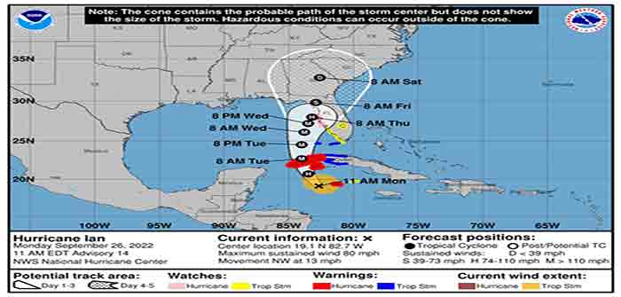
[National Hurricane Center Link] Ian is now a hurricane and expected to intensify quickly tonight and tomorrow exiting the Caribbean into the Gulf of Mexico as a major hurricane. Cone of probability for landfall arrival in the U.S. is still fluctuating. However, all west coast Florida residents should be finalizing their preparations today and tomorrow. Our chainsaws are sharpened, gear packed, toolboxes loaded. Today, we finish securing our property.
As a general rule, take cover from wind – but evacuate away from water. Dangerous coastal area storm surges are now predicted from Fort Myers north into Tampa Bay (south side of storm). Please outline your communication plan with your family. Select a specific person outside the area to be your immediate contact. That person then relays information to the rest of your family. Please do this [Example Why].
At 1100 AM EDT (1500 UTC), the center of Hurricane Ian was located near latitude 19.1 North, longitude 82.7 West. Ian is moving toward the northwest near 13 mph (20 km/h). A north-northwestward motion is expected to begin later today, followed by a northward motion on Tuesday with a slightly slower forward speed. A turn toward the north-northeast with a further reduction in forward speed is forecast on Wednesday. On the forecast track, the center of Ian is expected to pass near or west of the Cayman Islands today, and near or over western Cuba tonight and early Tuesday. Ian will then emerge over the southeastern Gulf of Mexico on Tuesday, pass west of the Florida Keys late Tuesday, and approach the west coast of Florida on Wednesday into Thursday. (link)

Right now, you are in control. Do not be alarmed – but take every preventative measure your individual situation needs. Work your hurricane plan and stay focused on what you do control. Proactive planning prevents piss-poor performance. Work the plan, step by step and focus on what is in front of you. Ignore the dark imaginings and turn off the national media. Pay attention to your local officials and local media.
Do your laundry. Sanitize and stage your water storage. Inventory your supplies. Organize your tools. Fill your freezer with water jugs to take up room and freeze. Test your generator. Stage your extension cords. Stage your battery powered devices. Test your weather radio. Take small steps to prepare. Secure your home. You are in full control.

The #1 priority is to keep calm. Keep stable. If other people around you are panicked, do not let it impact your plan. Stay focused. Stay organized. Stay in control. I cannot emphasize enough how important it is for everyone around you and your family.
Check your hurricane supplies of shelf-stable food, water, medicine and don’t forget pets. Prepare for the worst and hope for the best. Everything is replaceable, except you and your family. We have a lot of Treepers in the path of this storm. If you need assistance, use the comments section of any ‘Update thread’ to reach out, or use the email address in the upper right of the site.
Right now, you are in control. Have a solid plan, work that plan – stay busy, and don’t get caught up in the hysteria. Try to avoid national media hype. Stay updated via your local news stations. Monday afternoon/evening looks like the key day impact zones will be identified. Reach out to your neighbors; touch-base and check to see if they are okay or need anything. Community restoration begins before the storm arrives. Look out for each-other.
Regarding any evacuation plan, please pay attention to your local officials who will be coordinating with state Dept. of Transportation. As the path and impact zone of the storm becomes more predictable your local officials will alert to best route(s) for evacuation.
For those in the cone of uncertainty; remember, planning and proactive measures taken now can significantly reduce stress in the days ahead. Plan when to make the best decision on any evacuation (if needed) consider Monday the decision time-frame. As a general rule: take cover from wind – but evacuate away from water.
DAY ONE (Sat/Sun)…
Continue Reading